Wednesday, April 25, 2012

Ice Cave near Grants NM

Ice Cave and Bandera Volcana in New Mexico


When you travel by Grants NM, you may notice the signs advertising the Ice Cave. This is a Must-See in the El Malpais. It's privately run and the only ice cave accessible from Hwy 53. It May be 90 degrees outside but the cave is always cold, about 32 degrees.
To get to Ice Cave, take New Mexico Hwy 53 south from I-40 in Grants. It's a scenic drive past the Zuni mountains, not quite to the continental divide.

The road into Ice Cave
Keep a lookout for the Ice Cave sign. The dirt driveway is on the left and leads to an ample parking area among pine trees. At the end of the drive is the little store.

General Store
The General Store is the starting point for self guided walking tours of both the Bandera Volcano and the Ice Cave. The store was built in the 1930′s for the Zuni Mountain Railroad trade. It was in operation when the logging industry was in full swing. The ancient artifacts on display were found around the lava, dating back 800 to 1200 years.

Lava Flow
The lave flows are composed of jagged, broken basalt rock produced when the surface of a lava flow hardens around the still molten lava.

Twisted gnarly trees adapted to the shallow soils conditions, thriving in what appears as inhospitable.
The trail to the Ice Cave
Along the way to the Ice Cave there is a smaller cave, once used as a natural “refrigerator” by the owners, and minor caverns created by collapsed lava tubes.

72 steps down and 72 step back
The stairs are broken up with a couple of landings with benches to rest a bit. Once down there, it's awesome! The temperature in the cave never gets above 31 degrees F, so as rain water and snow melt seep in, it freezes. The ice floor is approximately 20 feet thick, with the deepest ice dating back 3,400 years!


That is solid ice on the floor of the cave.


The greens and oranges you see on the lava are lichen and Alpine moss, which is very rare this far south.


Ice Cave with frozen waterfall


Smaller cavern- This one is down in the bigger cave.

Onward to the volcano

The trail to the Bandera Volcano Crater is a half mile long and takes about 20 minutes to reach the view vantage point. An easy hike with some uphill climb.
 
For more information on Ice Cave and Bandera Volcano, click here. 


Trees growing in lava

There are at least 278 days of sunshine in Cibola county. the photo below is just to show off a cloudy day. No rain just clouds. On the way home we had a fabulous view of Mt. Taylor, 11,301 feet, north of Grants.

Mt. Taylor

Wednesday, March 28, 2012

Cabezon Peak

State road 550 takes you in a northwesterly direction from Bernalillo to the Cabezon Peak area. About 45 miles up 550 from Bernalillo the volcanic monolith can be seen sticking above the Rio Puerco Valley to the west.


A gravel and then dirt road heads seemingly towards nowhere and Cabezón. The road goes through the village of San Luis that is nothing more than a scattering of a few houses, half of them looking abandoned, or should be. The Rio Puerco valley is one of the most eroded river basins in the west, but it is a desert after all. Gravity works and so does erosion. The resulting landscape appears simultaneously desolate and enormous and inviting.


Take the left turn off the BLM dirt road to a rough parking area and trail head. There's a stretch of rutted dirt road that will rattle your dental fillings.


Looking across the Rio Puerco valley reveals its volcanic history. Splendid isolation awaits anyone willing to take the time and the view from the base of Cabezon peak. One of my fascinations with this area is the sun baked geology laid bare in all its layers.


The climb to the lower level of the base was easy to moderate as hiking goes. I did not attempt a climb to the top. It looks to be technical climbing rock faces above 100-200 feet. Not what I came prepared for in my day.

I did climb up the talus slope that you can just make out cradled between the branches of the deceased cypress or juniper above.


With camera swinging from my wrist, rocks the size of large bowling balls slipping beneath my feet, on ward and up ward I went.


But what a reward for my effort!


From above and behind me I saw this saddle in the rock formations. Looking accessible and ever more enticing, I climbed on. Had to find out what was on the other side. Curiosity killed the cat....


Ah-hhh, and satisfaction brought him back.


And again...


The descent was hard on the knees. Gravity works and some care was needed to avoid ending face-down on rough basalt rocks. However, I arrived back at the car safe and in one piece.

Instead of heading directly back the way I had driven in, I decided to take the BLM (Bureau of Land Management) road that loops around Cabezón, assuming it would deliver me back to the main highway at some point.


Cabezón Peak is a basalt monolith very like Devil's Tower in Wyoming, home of the UFO encounter in Close Encounters of the Third Kind. I did not have such an encounter, but I did have a Close Encounter of the Cow Kind...


Same cow, different view. There are horses also roaming around freely.


Volcanic past and erosion make for some fine photography...


This final photo is of the crumbling rock strata on the east side of the peak. It's easy to imagine that these formations hold some secret hide-away or other cultural evidence of ancient peoples passing here, like the Anasazi. They too may have been mightily impressed with the starkness of the Cabezon Peak area.

Monday, March 19, 2012

Fishing Near Grants

Quemado Lake Recreation Area, the 800-acre lake is located approximately 20 miles south of Quemado. The recreation area includes 
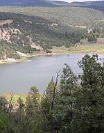
the 131 acre manmade trout lake with two ADA fishing piers, two boat ramps, seven developed campgrounds, one primitive campground, and links to more than seven miles of hiking trails. The lake is nestled between piñon-juniper woodlands and pine forests at an elevation of 7860 feet. Quemado is stocked all with rainbow trout in fall, winter and spring months. The lake offers year round trout fishing and warm water fishing for channel catfish and small mouth bass during the summer months. Other lakes in the Gila National Forest are Snow Lake and Lake Roberts.

Other Information
Campgrounds at Quemado Lake are available year around and are privately run. Juniper Campground opens from May to October offers 18 RV spaces with water and electrical hookups( $15/day ) and 18 single-family sites ($$). Pinon Campground opens May to October offers 23 single-family sites ($$). Reservations are taken for 2 group sites at Pinon for $35/day for a 30-person site or $55/day for a 75-person site. Juniper and Pinon are open from May 1 to September 30. Free primitive camping with vault toilets is available in the Cove and El Caso Campgrounds. Boat use is restricted to oars or electric motors.
No Potable Water. Potable water can be obtained in the Cove Campground from May - September. Fishing report- http://www.anglerguide.com/newmexico/index.cfm?TR_ID=316

Quemado Lake Overlook Trail: The trail leads through stands of ponderosa pines. The trail dead-ends at a rock outcrop overlooking the lake. A bench along the trail is available for resting and lake viewing. From the overlook, panoramic views of El Caso Peak, Castle Rock, and Quemado Lake provide excellent photographic opportunities. The trail connects to two additional trails that access El Caso Lookout and Sawmill Canyon for extended hiking. Many birds inhabit the area.

Directions
From Albuquerque, go west on I-40 to exit 89. Then travel south on 117 to Quemado. Travel west on Hwy 60 for 0.5 mile. Turn south on Hwy 32 and travel 16 miles to Hwy 103.

Friday, March 16, 2012

Acoma

www.skycity.com

Acoma Sky City is the oldest continuously inhabited city in the United States. It is the “must-see” in the Grants / Cibola county area for those tourists that don’t have much time or will enjoy a cultural experience.

In the year 1540 Francisco Vasques de Coronado visited Acoma on his way in search of the elusive seven cities of gold and found he was the first white man to ever enter the Sky City. Popular thought considers the location of Sky City as an ideal site for defense against enemies. The verbal history of the Acoma recalls their high top home site as a destination of their forefathers to a desirable place to live out their ceremonial lives with harvests and thanksgiving. The Acoma occupation of Sky City has been at least 800 years rivaled only by a neighbor to the east, the Taos pueblo.

A new permanent museum exhibit and cultural center was opened this April (2006). There is parking at the cultural center. Then a commuter bus takes visitors to the mesa top and the heritage site for a guided tour by an Acoma person. The tour will take 1-1/2 to 2 hours and will transport travelers into the Acoma view of their world, life and history. The Acoma are famous for their pottery and there are often vendors there for the curious and collectors. They enjoy their privacy and have some restrictions but nothing surprising. Ask questions and your Acoma hosts will delight you with humor and grace. Call 800 747 0181 to confirm operation times or making group reservations.

Public Events

May- St Maria Feast Day

August- Acoma Feast Day

September- Harvest Dance

December- Luminaria Tour


Zuni Pueblo

The Zuni were also visited by the intrepid Spanish explorer, Coronado. The Our Lady of Guadalupe Mission is all that remains of the Spanish mission occupation years. Our Lady of Guadalupe mission is located in the older middle village and can be visited with reservations at the heritage center. You will find 24 murals of Zuni kachinas, or messengers of their gods, painted on the interior walls of the church. This is one of their most sacred places of reverence and reflection. They have remained traditional by their tenacity and remoteness.

Travelers can get a look into life, past and present, as Zuni at the A:shiwi A:wan Museum & Heritage Center. It is easily accessed from Hwy 53 with limited visiting hours. The Zuni are incredible craftsmen and make beautiful inlay jewelry and furnishings. Many exquisite pieces are on display at the heritage center. Call (505) 782-4403.

Then join in the fun at the Ancient Way Festival during the first two weeks of October. It all happens along the traditional trail between Grants and Zuni pueblo, Ancient Way Scenic Route 53, beginning at Grants KOA. Enjoy music, local flavors in food, Zuni dancers and storytellers, and more. Relax in the cool evening air at the end of each day at the KOA in Grants, (505)287-4376).


Monday, March 12, 2012

El Malpais National Monument

El Malpais is Spanish for "the badlands." It is volcanic features such as lava flows, cinder cones, pressure ridges and complex lava tube systems that dominate the landscape.

Fairly new to the National Park System, El Malpais National Monument and Conservation Area was established in 1987. Its 114,277 acres is managed in a joint effort between the National Park Service, forest service, and the Bureau of Land Management. El Malpais hosts more than 100,000 visitors annually; visitation is highest in July and August and lowest in December and January.

General Information

Seasons / Hours

  • The monument is almost always open to visitors except for the Sandstone Bluffs Overlook that closes at dusk. Winter hours are posted online.
  • El Malpais NPS Information Center is open daily 8:30 am to 4:30 pm. It is closed on Thanksgiving Day, Christmas Day and New Year's Day.
  • BLM's El Malpais Ranger Station on NM Highway 117 is also open 8:30 am to 4:30 pm daily.

Rates & Fees

Still no fees charged at El Malpais, but donations are accepted and appreciated.

Visitor Center

El Malpais Information Center is located 23 miles south of Grants, on NM Highway 53. It contains exhibits about volcanology and natural history, a bookstore and regional information. Picnic tables, water and restrooms are also available here.

Programs/Activities
Ranger guided activities are available during the summer weekends. These include hikes, programs, cave explorations and evening bat flights. Contact El Malpais Information Center for details. Ranger guided programs for educational groups are available by reservation. Contact monument headquarters for information.

Food/Supplies
None in the monument. Restaurants, service stations, and grocery stores are avail
able in nearby Grants.

Accessibility
Visitor parking is available at all sites, and these areas have room for a limited number of RVs or buses.
Accessibility is limited. A portion of Sandstone Bluffs Overlook is wheelchair accessible as is a short loop trail at the Zuni-Acoma Trailhead. Restroom facilities at areas throughout the monument are accessible. El Malpais Information Center is also accessible.

Reservations/Permits
All overnight and backcountry use requires a free permit. Some caves require a Special Use Permit. Educational groups need to make reservations for ranger-led activities.

Climate, Geography, Setting

Setting

El Malpais is located south of Grants, New Mexico. Two major state highways border the monument and conservation area; both are accessed via Interstate 40. Exit 89, east of Grants, travels along NM Highway 117, which forms the eastern boundary.

The BLM's El Malpais Ranger Station is located 9 miles south on 117 and is open 8:30 am to 4:30 pm daily. Exit 81, west of Grants, travels along NM Highway 53, which forms the northwestern boundary. NPS's El Malpais Information Center is located 23 miles south of this exit and is open 8:30 am - 4:30 pm daily.

Climate

El Malpais ranges in elevation from 6500 to 8300 ft. The weather in northwestern New Mexico is unpredictable and visitors should be prepared for all conditions throughout the year. Thunderstorms are a common occurrence during summer afternoons and lightning poses a hazard to hikers. Winter snowstorms are common and nights are cold with below freezing temperatures.

Getting There

To the Monument
The best access to the monument is by private automobile. The two major state highways bordering the monument and conservation area are accessed via Interstate 40. Exit 89, east of Grants, will take you along NM 117 which forms the eastern boundary. Exit 81, west of Grants, will take you along NM 53 which forms the northwestern boundary.

In the Monument
Private automobile for paved roads and the information center; high clearance, four-wheel drive vehicles are recommended for travel on dirt roads and are required for travel on primitive roads.

Description

Cultural History

For more than 10,000 years people have interacted with the El Malpais landscape. Historic and archeological sites provide reminders of past times. More than mere artifacts, these cultural resources are kept alive by the spiritual and physical presence of contemporary Indian groups, including the Puebloan peoples of Acoma, Laguna and Zuni, and the Ramah Navajo. These tribes continue their ancestral uses of El Malpais including gathering herbs and medicines, paying respect, and renewing ties.

Natural History

The monument office, located on highway 53, is everything to do with the volcanoes, lava flows and associated features dating from 200,000 to 2,000 years old. Sandstone bluffs and mesas border the eastern side, providing access to a vast wilderness.

The lava flows are unique ecosystem with animals and plants living on the rocks. Birding is a popular activity in the Malpais. Or explore the caves and lava tubes, and experience the flows from within.

Things To Do

There are many areas awaiting your exploration of El Malpais. Below are some of the main visitor use areas that offer sightseeing, hiking, caving, photography and birding. It is a good idea to carry water when exploring any of these areas.

Auto & 4WD Touring

Two state highways provide paved access to many areas in the monument. County Road 42, a dirt road, provides access to the backcountry's primitive dirt roads. These roads may be impassable when wet. Travel on these roads is restricted to high clearance vehicles and those with four-wheel drive are preferred.

Sandstone Bluffs Overlook
An easy drive on a dirt road leads to a ridge of sandstone. From here you are offered excellent vistas of the El Malpais lava flows and the surrounding countryside.

Hiking & Climbing

Hiking routes exist throughout the monument. Most traverse lava flows and are marked with rock cairns. Few dirt routes exist. Backcountry hiking and cave exploration is permitted, but no water is available. Topographical maps and a compass or GPS unit are strongly suggested for backcountry exploration.

Use extreme caution hiking on lava terrain -- it is sharp and unstable! Never hike or cave alone.

Zuni-Acoma Trail
This ancient puebloan trail follows a trade route between Zuni and Acoma Pueblos. This is a strenuous 7-mile, one-way hike across 4 of the major lava flows in this region.

La Ventana Natural Arch (BLM)
One of the largest of New Mexico's natural arches, La Ventana was eroded from sandstone that dates back to the age of dinosaurs.

Cebolla Wilderness (BLM)
East of NM 117 lie some 62,000 acres of forested rimrock country. This wilderness is rich in prehistoric petroglyphs and historic homesteads.

Lava Falls Area
Explore lava features and plant adaptations unique to McCartys flow, the youngest lava flow in this region.

El Calderon Area
Forested and offering year-round opportunities, this area includes Junction Cave, Double Sinks, El Calderon cinder cone, lava flows and sandstone formations.
Chain of Craters (BLM)
Magma found a weak area here and created a rift lined by 30 cinder cones.

West Malpais Wilderness (BLM)
Lava surrounds a large ponderosa pine parkland known as Hole-in-the-Wall.

Caving

Visitors planning to explore lava tube caves need to come prepared with warm clothing, protective headgear, three sources of light, and leather gloves. Sturdy hiking boots are required when hiking on lava terrain and day packs with water, snacks, rain gear, first aid kit and sunscreen are suggested. Backcountry exploration requires planning and rangers at El Malpais Information Center can provide assistance prior to your visit.

Big Tubes Area
Lava tubes can be huge and this area is home to one of the largest systems in North America. A cairn route leads to Four Windows and Big Skylight Caves, and to Caterpillar and Seven Bridges Collapses.

El Calderon Area
Forested and offering year-round opportunities, this area includes Junction Cave, Double Sinks, El Calderon cinder cone, lava flows and sandstone formations. There are picnic sites available here.

Camping & Lodging

The monument does not have an established campground. Primitive camping is allowed and all overnight use requires a backcountry permit available from El Malpais Information Center. The back country camper is virtually certain of isolation.

Then when bathrooms and showers are preferable, there is the Grants KOA near Grants. The KOA is always a good experience.

Monday, January 4, 2010

Where in the world is Grants KOA?

50 miles from nowhere.....We're 360 miles west of Amarillo Texas & 250 east of Flagstaff Arizona (75 miles west of Albuquerque) on I-40 in New Mexico.